Browsed by
Tag: Cajamarca

Mudslides, mountains and missing roads!

Mudslides, mountains and missing roads!


Hello!

We are still a bit shocked about the news ( Mocoa devastation ) from Mocoa in Colombia! We were there only 4 weeks ago and are a bit discombobulated by this turn of events especially as we were camped down by the river ourselves.

The situation here in Peru has also been quite discomfiting and seeing the daily news reports of flooding, mudslides, destruction and death puts our safe, tame, easy European existence into stark perspective.

We are now in Caraz in the Cordillera Blanca after a fairly epic journey from Cajamarca.

The town of Cajamarca was a pleasant surprise and so nice we ended up staying three days. Full of locals wandering around in their odd hats, zillions of shops selling cheese – Cajamarca is a major cheese producing region ( we saw milk churns awaiting collection everywhere ) although Peruvian cheese isn’t exactly ( a personal opinion. Some people think it’s excellent ) anything to write or blog home about; a bit rubbery and squeaks when chewed; you could probably make good squash balls with it. –  a great guinea-pig themed bar, pretty colonial streets and a very tranquil hostel with a lovely garden and all at the near perfect altitude of 2700m – although it did rain a bit. Actually, quite a lot of rain but,  this is Peru in the rainy season!

Cajamarca is also where Atahualpa, King of Quito, conqueror of the Incas and his 80,000 strong army, met his untimely and pivotal death at the hands of Fransisco Pizarro with his 169 conquistadors and 69 horses.

Tranquil room next to the hostel garden.
Hats! Apparently, according to a guide, they cost 2000 Peruvian Soles – £500!!! Seems an awful lot for a hat but we gather they’re a treasured possession, a bit like a car, horse or Eastenders box-set! 🙂
Being forced to pose outside our lovely hostel.
Selling milk outside one of the many cheese shops.
Peruvian version of the ubiquitous asian tuk-tuk.
McCuy’s. Guinea-Pig themed bar.
Arty Peruvian beer.
Statue of Atahualpa overlooking Cajamarca.
Knitting! We saw lots of women knitting or hand-spinning wool.
Women hand spinning wool on the go.
Hatted woman and traditional multi-layered dress.
Lots of towns had these collection centres where you could drop off supplies to help those affected by the flooding.
Couldn’t really get a decent photo as it was all roped off but this is supposed to be the room where Atahualpa was held by the Spanish conquistadores before they killed him after promising not to, if he filled the room with gold and silver.

Due to time constraints and trying to deal with the rain/mudslide issues, we took a bus from Cajamarca to Cajabamba where we spent the night. Met a couple of other cycle-tourists here and spent a nice evening drinking beer and talking biking. It’s always nice to talk to other cycling lunatics….  🙂

From Cajabamba we cycled to Huamachuco where we paid a visit to the ruined fortress of Markahuamachuco, one of the most significant archaeological sites in northern Peru yet almost unknown as a place to visit. Sitting at 3600m on a mesa 5 kilometers long and 500 meters wide, with a commanding view of the surroundings, it was probably even more impressive than Kuelap to visit.

Tourist posing…
Big rock, little rock, tiny pebble. The builders of the fortress used this visually pleasing style of construction.
We loved this doorway and its commanding view.
Another great doorway.
Great location.

Many of the buildings are defensively built with double or even triple walls.
and the rain headed our way…..

On the way to Huamachuco we spotted these people hiding in the bottom of a gully making chicha.

After Huamachuco, we took another couple of buses ( saving 2 or 3 days of cycling ) to the hamlet of Angasmarca where we hoped to get a bus to Pallasca ( saving a couple more days of our remaining 2 weeks ) and then cycle from there to Huaraz and the Cordillera Blanca via the Canon del Pato.

However, we discovered in Angasmarca, that no transport appeared to be heading to Pallasca so we decided to cycle. Several blogs said that the scenery was spectacular and the significant climbs were paved and not too steep. The official government website showing current rain-related road closures, had previously reported that the road was closed but no longer did and the people we spoke to only mentioned partial blockages. Some of the above was true, some of it really wasn’t!

Interesting method of road repair.
Three smiling boys and their chickens.
!
Discussing netted chicken prices.
Riding into an empty no horse town.
Crossing the first mud slide on the way to Pallasca.
The second mud/rock slide encounter. Feeling somewhat nervous here.
On the way to Pallasca – looking back at the stunning scenery, windy descent and equally twisty climb.
At the bottom of the climb to Pallasca. The people we spoke to said that the blocked roads were impassable to vehicles but bikes should be OK,  so we ignored the sign and carried on.
Yet another cycle friendly blockage.
Shortly before we got here, a donkey-riding woman said that the road had gone – at least that’s what we thought she might have said. She wasn’t exaggerating!
Now we knew why there was a road closed sign! We were definitely very, very nervous here. Another person we met said it was possible to get through with a donkey so we should be ok! Some of those boulders were as big as a house. Why the people we spoke to in Angasmarca didn’t mention this slight impediment to travel we have no idea. The man we spoke to said that it had been like this for 15 days! We both got our boots full of water crossing this – the current was strong, the water deep and the mountainside above us looked scarily unstable.
It was only after we crossed the mini-ravine and were pushing/heaving the bikes along a muddy track that skirted the missing road, that we realised that there was nothing supporting the remnant of road we’d been inching along!
Another section of collapsed road that we had to scramble our bikes around.

By the time we made it back to the undamaged road we were wet, cold, exhausted and still 7km away from Pallasca with 500m of climbing to do. Fortunately, some electrical engineers were happy to give us a lift in their truck.

Pallasca sits at 3600m and was cold, damp and pretty miserable. The 2-star hotel was closed so we had to plump for a very basic room in a £4 a night hospedaje.

Making tea on our petrol stove on the floor of our room in the Pallasca Hilton.
Completely safe electric shower in the Hilton.

The following morning we made porridge on our stove in the room and left our non-luxurious accommodation.

There are two roads out of Pallasca. One is a 130km up and down mountainous road that may or not be paved. The other, a tarmac surfaced 80km,  2400m descent through a canyon. We were told that the latter had a few issues and was closed to vehicles but that we should be ok to get through with the bikes. Decision made!

As we left Pallasca the views were stunning.
A few small rocks scattered on the tarmac and views to die for…. Nearly!
Bloodstained and covered in mud after our first encounter with a live mudslide! Gloopy, viscous mud and sharp rocks up to Steve’s knees. We struggled to haul the bikes though it. A few minutes prior to this, a rock the size of a fridge smashed down 6 feet away from us! – needless to say, we didn’t stop to take photographs!

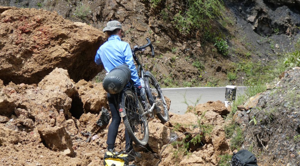
Things continued to deteriorate! The following photos simply don’t capture how big the swathe of destruction was. We had to unload the bikes and literally haul and drag them across 500m of unstable rock, mud, boulders and torrents of water with the whole precarious mountainside looming above us; then go back for the panniers and do it again! Really fucking scary! Well, we did come here for an adventure!

On the approach to Mordor.
A local who was also braving the annihilated mountainside decided to help us. You can just make out Michelle ( right mouse-click and select “open in a new tab” or download, to see the image full size ) in her blue top in the background for some idea of the size of the landslide.
Michelle nearly there with her bike – only a 200m or so to go. You need to do the “right mouse-click and select “open in a new tab” or download” thing again to see her….. Sorry to make you do geek stuff! :p
Wouldn’t want to do that again!

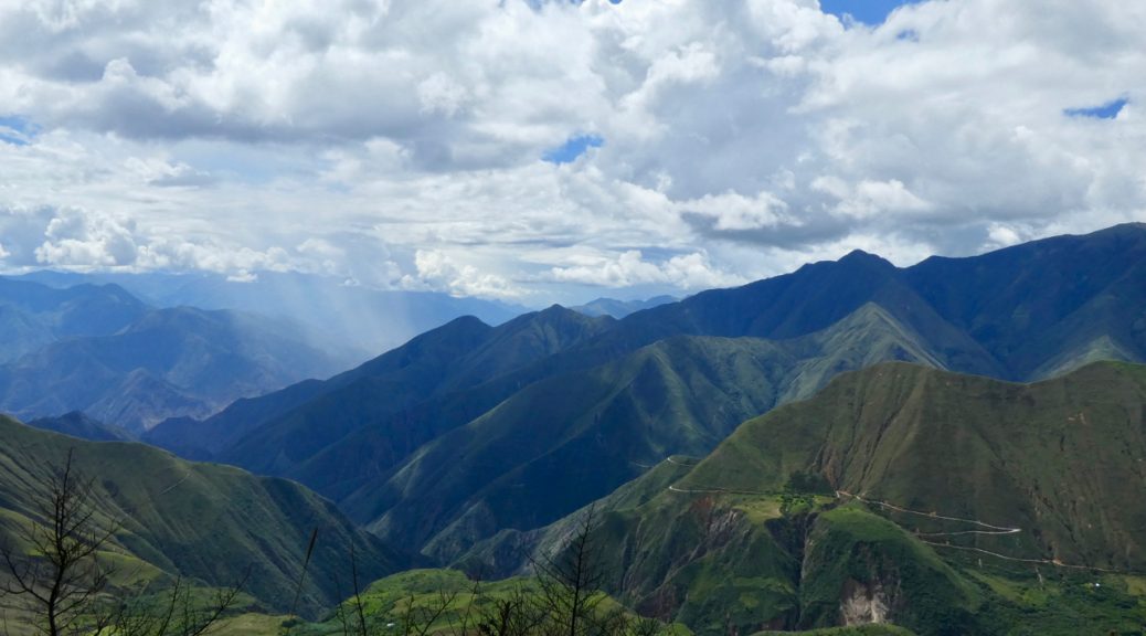
After we’d survived the crossing of Mordor, we were back on a mostly paved road although long sections were buried under mud and some bits partially blocked. The scenery as ever, continued to impress with it’s scale and grandeur.

Descending down into the canyon. Spot the cyclist!
Impressively big.

Eventually we reached the bottom of our 80km “easy downhill” road and the “town” of Chuquicara sitting at the bottom of the Canon del Pato. Chuquicara is a hot, dusty dump at a lowly 500m of altitude. The only accommodation was a really scungy restaurant/hospedaje ( other cyclists describe bedsheets that hadn’t been changed in months! 🙁 ). After eating a much needed but decidedly dodgy meal, we decided to give it a miss and despite our filthy, exhausted state, cycled on a further 20km and camped next to a sort of restaurant at the side of the road.

At the bottom of the Canon del Pato.

The following morning we set off up the hot canyon. After 20km and 300m of climbing we decided to get a lift. Michelle wasn’t feeling well, we were both very tired from the previous two days exertions and the canyon wasn’t living up to expectations. Other people/cyclists had said the canyon was spectacular to ride with 37 tunnels to negotiate and vast, towering walls of rock to slither through. We thought the previous days descent was pretty similar and didn’t regret making the rest of the journey to Caraz by bus.

We now have a few days here in the Cordillera Blanca before getting a bus to Lima and our flight home. We don’t know if we’ll do any more cycling now but we’ll see. Michelle appears to have acquired a stomach bug from the scummy restaurant in Chuquicara and currently isn’t very perky but we hope to try and do a couple of day walks or cycles to see some of the spectacular mountain scenery that makes this area one of the biggest attractions in Peru.

With any luck ( or not, depending on your perspective ) you might get another blog update before we leave Lima. If not, thanks for reading and see some of you in London! xxx
Torrential rain, trapped and tyred!

Torrential rain, trapped and tyred!

Hola chicos y chicas.

We’ve had a long gap mainly due to not much to report and difficulties getting good wi-fi and a mobile phone sim.

When we first started cycling together back in 1989, there was no email, no internet and no mobile phones. When we set out to cycle in Africa, my family thought I was actually on the way to China ( the Tianamen Square massacre scuppered that plan ) so the first thing they knew otherwise, was an airmail letter from Nairobi! It was a very satisfying feeling to know that no-one knew where you were and you felt that you were having a proper adventure.

Gaps in communication of several weeks were usual and people didn’t really worry; the normal way of communicating with travellers was via poste restante – You told people where you were heading and they then wrote to you i.e. Steve Willey, POSTE RESTANTE, Lilongwe, Malawi, where your mail would be held for up to a month. You then went to the main post office in your destination city, showed your passport and collected any mail being held for you. When you wrote back, your letter might get passed around or someone would make photocopies and pass them around. Simples. The system is still in use so maybe we should all abandon FB, blogs, etc. and resort to non-instantaneous old-school letter writing!

Anyway, we digress.

From San Ignacio our destination was the town of Chachapoyas, a four day ride away via very asian feeling paddy fields, a short cut we’d read about that involved a very turbulent river crossing from the “port” of Rio Maranon on the Utcubamba river and a wild-camp at a mosquito and sand-fly infested petrol station.

Paddy fields and palm trees – felt very Asian.
Pesticide spraying the rice sans any consideration for the workers lungs or health! 🙁
On the way to Rio Maranon.
The port of Rio Maranon!
Rio Maranon hyper-market.
A very rough looking river. We’re brave. We weren’t nervous! haha!
Peruvian super-ferry. Fare = US$1.80
hi-tech loading ramp.
Our petrol station camp spot. People are so nice though. When we asked for some water so that we could cook some dinner, the wife of the owner came along and asked if we’d like some rice – we said yes. A short while later, she called us up to the flat above the station and fed us a meal of rice, chorizo and eggs and refused to take any payment!

After our interesting river crossing, we pedalled on a further 80km through hot, dusty, countryside to the sleepy junction town of Pedro Ruiz Gallo where another bug struck and Steve had a very disturbed night! We’d been looking forward to continuing our cycle up the very scenic Utcubamba gorge but decided to feed Steve more movement-stopping drugs and take a mini-bus to Chachapoyas. The original plan was to leave Chachapoyas the following day and cycle 40km to the tiny village of Nuevo Tingo, the gateway to the ruined city of Kuelap. Plans are one thing, stomach bugs are another! Bug No2 confined us to town for 4 days whilst things took their course. Felt very sorry for Michelle getting bored stiff  – not exactly much to do except for a small cultural museum that contrived to be closed every time she went to visit. The only saving grace was the nice hostel we were staying in.

Peaceful hostel courtyard.

Once Steve was mostly recovered, we had an easy 40km cycle – 16km freewheel downhill followed by a lovely ride up a gently sloping canyon road to Tingo where we camped in the grounds of a hostel. The following day we left the bikes and our gear there and grabbed a lift 2km up to Nuevo Tingo where we took the new cable car to Kuelap. This new service takes 20 mins instead of a 3 hour hike! Last year Kuelap saw 40,000 visitors. They hope to triple that in the next year now access is easier although there’s still no airport in the Chachapoyas region so the increase in visitor numbers will be slow.

The fortress of Kuelap or Cuélap, is a walled city associated with the Chachapoyas culture built in 6th century AD. It sits at an elevation of 3000m and consists of more than four hundred buildings surrounded by massive exterior stone walls. The complex is situated on a ridge overlooking the Utcubamba Valley in northern Peru and roughly 600 metres long and 110 metres wide. It could have been built to defend against the Huari or others, but evidence of hostile groups at the site is minimal.

Some of the walls are decorated with tiled friezes in rhomboid or zigzag patterns which are a hallmark of Chachapoya architecture. The mural decorations include representations of the eyes of felines, snakes and birds, all different gods to the Chachapoya.
Kuelap round houses.
Frieze detail.
Bromeliads

One of the 400 or so round buildings on the site.
It’s not Machu Pikchu but very impressive nevertheless and in a great location.
Given that it’s one of the biggest archaeological sites in Peru, Kuelap doesn’t exactly have much in the way of tourist infrastructure or easy access – yet! The new cable car should eventually help to change all that.
New cable cars – only been running 4 weeks. You can just make out in the background the old hiking trail to the city that the cars replace.
Entrance way that only allowed one person at a time. As you can see, things are in need of restoration and are being supported in a typically Peruvian fashion.
More temporary support work….
Proper restoration work is badly needed.
One of the most interesting structures is the inverted cone-shaped tintero (inkwell). Pretty difficult to build with modern techniques and materials. Impressive for the C6th.


From Kuelap, we had another easy 50km day following the Utcubamba river up a pretty, gently sloping gorge road ( very reminiscent of small French alpine D roads ) to the small mountain town of Leimebamba where we stopped for the night before tackling our first big Peruvian climb.

Following the Utcubamba river.

From Leimebamba we aimed to spend 3 days or so cycling to Cajamarca, some 250km away. The first day saw us cycle uphill for 30km to a pass at 3600m – not too tough really except that we twice got attacked by bees ( no action on our part – just sudden unprovoked attacks! ) resulting in Steve getting stung 3 times and us dropping the bikes on the road, running away and then sneaking very, very slowly back to get them once the bees appeared to have gone away.

Looking back down at Leimebamba sitting in a fold in the mountains at 2000m.
The pass above Leimebamba.
Stunning views on the other side of the pass made the effort of the 1600m climb and the bee stings all worthwhile.
The view took our breath away. Photos really can’t capture it.
The valley floor in the foreground was maybe a 1000m below us. Our destination was the town of Balzas 2800m lower down.
Awesome.

The 64km, 2 hour freewheel down to Balzas in the valley was excellent although the increase in temperature not so excellent. 17C at the top and a sauna steamy 40C at the bottom. We’d read from an overland travel blog that there was a good wild-camping spot 5km on from Balzas; 200m higher up and in theory slightly cooler.  So once we’d fixed a slow puncture and some scumbag kids had stolen my e-cigarette, we left Balzas for our not so good as it turned out camp spot. Very rocky, very hot and very insecty. That’s a new word I just invented.

Our not so good wild-camping spot.

The following morning the alarm went off at 4:50 and we were on the road by 6:30 in a bid to try and gain a bit of altitude and cooler air before it became unbearably hot. The target for the day was the town of Celendin, 55km away and over another 3200m pass – 2100m of climbing ahead of us.

After a 1000m of climbing we or rather Steve gave up and we got a lift to Celendin and then from there, a mini-bus to Cajamarca.

We’ve been on the road for 3 1/2 months now. The cycling has been very rewarding, the countries and people experiences sublime but, we’re tired. The 2500km of cycling we’ve done so far has been very physically demanding at times and we’re now running out of energy.

We’d like to cycle a bit more – up into the Cordillera Blanca and on to the city of Huaraz where we plan to get a bus to Lima for our flight home in a couple of weeks – but have a couple of issues to contend with.

Some of the roads are very tough with some 4000m passes however, the main problem is due to the extreme rainfall northern Peru has been experiencing lately causing widespread flooding, mud slides and chaos.

There are currently no buses running from either here in Cajamarca or Huaraz to Lima because the rain has destroyed several critical roads and bridges or blocked them with mud slides! The main coast road north from Lima is closed causing major problems. 80 people have died so far, 140,000 homes destroyed or damaged and at least 650,000 people displaced or affected! Additionally, as a result of the transport issues, some food prices have increased or dropped because people can’t export their produce and fuel shortages and associated price increases are affecting some areas.

The road from Huaraz to Lima was open briefly a couple of days ago but further heavy rain has closed it again with more forecast for the next 2 weeks!

We may well be stuck and there’s a possibility that we won’t be able to get to Lima in time for our flight home!

At the moment the plan is to take a bus a bit further south then cycle the remaining 500km to Huaraz and hope that the situation improves enough over the next 10 days to allow us to get a bus to Lima.

What we don’t know is – will the roads re-open in time and if they do for how long? how many other travellers are stuck in Huaraz and will there be space on a bus if the roads do re-open? We’ll be cycling on some very tiny, high, remote dirt roads that themselves may or may not have rain-related issues. Exciting!

Watch this space!